We had quite a storm in Shimane a few days back, and there were a lot of landslides and flooding. We did not suffer any damage at our house, but the surrounding area is riddled with road closures and traffic due to road repairs. I have stayed off of the local roads for a few days, as I figured they would be rife with gravel & sand, and would not be safe for a motorcycle. However, the passing storm has brought about beautifully clear skies and pleasant weather, so today I gave in and risked the roads.
The Goal: Ride up route 9 to Aquas and purchase a souvenir/gift for a friend, then turn right into the mountains and find a roundabout way home.
The ride to Aquas was pretty straight forward, as there were no delays or road closings, but there were a number of landslides along the road that had already cleared up. The only hazard I faced along the way was a rather large book (yellow pages?) which was sitting in the right third of my lane on the bypass.
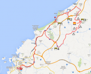
After picking up some stickers and crackers at the gift shop, I crossed the street from Aquas and took a photo with the iconic Aquas walking bridge (red pin on the map). The sky was beautiful, and a short ride down the road I found a spot on the beach where a couple of guys were enjoying some late afternoon wake boarding.
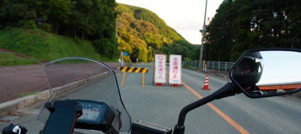
From Aquas I took the immediate right inland on the route 300 to Arifuku onsen. Unfortunately, I only made it about 500 meters before I met my first closed road. I turned back and continued up route 9 a bit further and tried again at route 299, only to find a second barrier to my return home. I was forced to backtrack and head back up route 9 again to route 297 towards Atoichi, and from their towards the Green Line into Kanagi. I was intentionally trying to avoid this road, as I love it and take it often and was hoping to find some new interesting paths through the mountains.
I was glad to see that I finally found a road that was open, but this path was rife with hazards. I only took photos of a few, but there were many collapse walls on the uphill side, and areas were the dowhill side of the road was washed out. It was a constant slalom of single lane traffic spots around blind corners, and it was a rather stressful ride. The final photo below is of the eastern windmill access road, which is where I often go to take photos. Luckily the western access road was open and the sun was just starting to set.
I love riding these windmill access roads for a few reasons; the views are spectacular, the roads are new and well made, and there is never anybody else there. For these reasons, I find it a great place to ride and to take photos. This may be the first time I took photos on the western route, and I found myself glad that the eastern route was blocked.
Overall, it was a great day for a ride. Finding my way home past the closures and hazards was a fun challenge, and I think that I just may have captured a photo or two worth entering in the Hamada photo contest…


